End of MERRByS Operation Pilot Service

We are sad to announce that life extension of TechDemoSat-1 for supporting MERRByS is coming to an end. Routine GNSS-R data collection will cease this weekend (16th Dec 2018), and the GNSS reflectometry service will not resume in January. The SGR-ReSI was just one of the 8 technology experiments, and the final demonstration on TDS-1 is the de-orbit sail; this will be deployed early in 2019.

SSTL and NOC have plans for the flight of future GNSS Reflectometry instruments to continue what TDS-1 started, so watch this space!

In the meantime, we will keep maintaining the website and data repository.

Thank you for your ongoing interest in and participation with this GNSS-Reflectometry project. We continue to welcome feedback into a potential future GNSS-R service.


New Data Available

There are three significant updates to announce for the MERRByS service.

Mission extension – Continuous GNSS-R

The TDS-1 mission ended and since February 2018 it has been operating with a mission extension. The SGR-ReSI is now running 7/7 days, rather than the 2/8 as in the first 3 years. This is increasing the coverage and sampling by a factor of 4.

To support continuous operations the DDMs are now selected onboard to only those with antenna gain > 0dB, and compressed using a variable quantisation rate. We are not expecting users to see differences from this compression process. Further details are available on request and will be put in the Product Manual in due course. The L1b version has been increased to V0.71 to support the compression.

Data update every 6 hours

The 2nd announcement is that MERRByS is now being updated every 6 hours with new data to the FTP server. There are two streams of data available.

Standard Users:

  • 1 Month latency
  • Apply for account password, as before by the registration page

Fast Data Users:

  • 24-48 hour latency
  • Providing pilot data service – demo of data release within 1-2 days of measurement
    • Additional interaction with SSTL & NOC – support and feedback
    • Apply on the registration page with your request

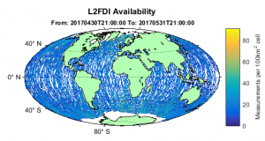
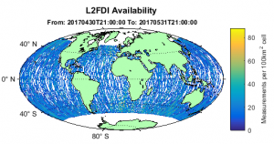
New Ocean Wind Product

The 3rd announcement is that the L2_CBRE (Calibrated Bistatic Radar Equation) V0.5 Algorithm has been incorporated into MERRByS. The National Oceanography Centre (NOC) have developed this algorithm to use additional receiver and transmitter corrections to improves the wind-speed measurement. This is the algorithm as presented in GNSS+R 2017, incorporated into MERRByS.

It should be noted that this is currently preliminary work and is expected to be updated soon with a new version. Currently the coverage is sparse due to a known flagging issue.

We will currently be putting the CBRE and FDI ocean wind speed products alongside each other.

Direct Signal Power Update

The focus for GNSS-Reflectometry with the SGR-ReSI is to measure geophysical parameters such as ocean wind-speed and mean-squared-slope. This is performed by receiving the GPS navigation signals reflected from the Earth, measuring the power and signal distortion caused by the reflection then inferring back the parameters of the surface.

One of the factors that affect the reflection power measurement is the power level transmitted by each of the GNSS satellites. There is variation between each GPS transmitter and over their antenna patterns.

The SGR-ReSI uses the signals directly from the GPS transmitters for navigation and for the steering of the DDM processing to the location of the reflection. The power of the direct signals is measured onboard with a similar setup to that used for the reflections.

With the last update to MERRByS the direct signal power measurements were exported to NetCDF file and released. These contain the time-series of our direct signal power measurments. The DirectSignalPower.nc files have now been replaced on MERRByS with version 0.3. Additional fields have been added and a number of corrections to the fields, so that now radiometric calibration can be performed on the data.

The Direct Signal Power file is in NetCDF format and contains self documenting headers that can be inspected from the file itself. There are some minor updates in a new version of the  MERRByS Product Manual V4.

Update of Level 2 data

The Level 2 FDI wind-speed data has been updated to include measurements at high and low latitudes.

The processing remains FDI V1.11.

Originally a filter of 55 degree latitude was used to be sure that sea ice was excluded from the retrieval. The new approach filters using a sea-ice map so that our measurements continue closer to the Arctic and Antarctic.

Below are the availability of L2 wind-speed product,

With new sea ice filter:

Original sea ice filter by latitude: